No snow! Not on the tracks I was following anyway. A day along broad ridges either wooded or with greenish fields of grass that had suffered a lot over the winter.
After purchasing my lunch, a bread with cheese on top and ham inside, I checked out the National Park Visitor Centre (closed being the weekend) and the Tourist Information office (could not advise on future accomodation options as they were outside the municipality - not very helpful).
I climbed out of town, which is pretty from a distance with its red tiled roofs. All the town was recently built when the Djerdap dam was constructed and the old town flooded. After a steep climb it was down again to a inlet of the lake created by the dam. A lot of exposed sand, it looked like a tidal estuary but clearly was not. Then another steep climb through oak and beech on a track and followed by a road section to the village of Miroc.
After that a long ridge walk passing farms, mostly with grass fields but with the occasional orchard or small field used for maize. Late in the afternoon I reached the Buronov caves where again a stream disappears into a cave. There are many large cave systems in the area.
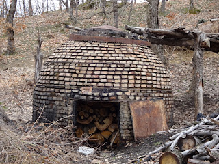
One sight today which pleased me were the flowers: primroses, little blue things with six thin petals (scilla?), and wild, yellow crocuses. A sign of spring along with the occasional yellow Wytch hazel blossoms, and the bursting green buds on the Elderberry bushes. Another point of interest were the conical structures used to make charcoal that dot the area.
As I was approaching the main footpath up Veliki Strbac a man from one of the many farmhouses offered me a "schnapps". As I had almost completed the day's walk I accepted a small glass (but prudently refused a second). It was very good and smooth. The bottle had some wild plant in it, "pirin" I think he said.
I am now camped among trees hoping for a fine day tomorrow so I can see the view of the "Iron Gates" of the Danube for the Strbac summits.
32.4 kilometres walked today with an ascent of 1380 metres. From Donji Milanovic to Monsa a gpx file of my route can be found on Wikiloc.com, and WanderMap.net. The route can also be downloaded from Viewranger.com as johnpon0027. From Monsa onwards a gpx file of my route can be found on wikiloc.com and wandermap.net. The route can also be found on my.ViewRanger.com as johnpon0028.
 |
| Building for making charcoal |
 |
| Traditional haystacks with blue flowers among grass |
No comments:
Post a Comment